Getting to the (Data) Point
In this research summary, we summarize a synthesis of spatial invasive plant data availability and applications in the United States
Fusco, E.J., Beaury, E.M., Bradley, B.A. et al. The invasive plant data landscape: a synthesis of spatial data and applications for research and management in the United States. Landsc Ecol (2023). https://doi.org/10.1007/s10980-023-01623-z
Summary written by Audrey Bowe, edited by Carrie Brown-Lima
Summary
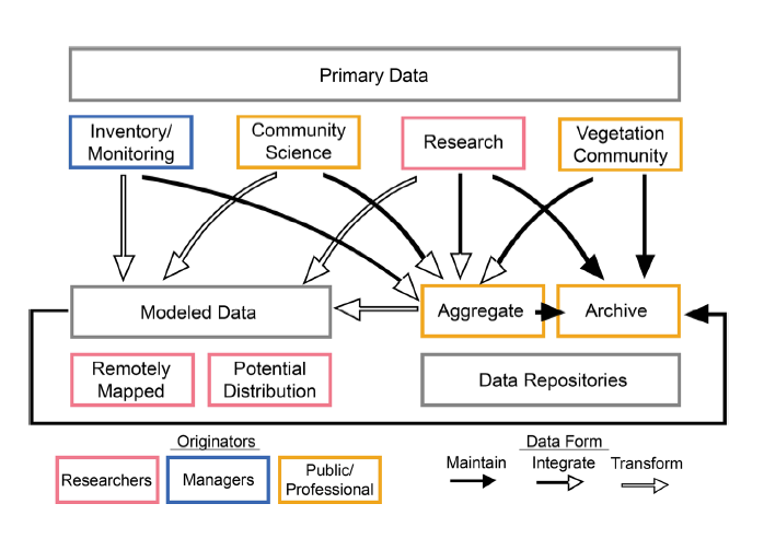
Knowing where plants are is an essential component to effective invasive species prevention, management, and research. Particularly in the context of climate change, knowing where invasive plants exist on the landscape can help understand where they’re likely to spread and support early detection and rapid response (EDRR) to climate-driven invaders. In recent decades, invasive species data have been more widely collected and are increasingly accessible, however gaps and limitations in this information still exist. In this study, Fusco et al. seek to improve the understanding and use of these data among researchers and practitioners by synthesizing information on spatial data types and datasets available on invasive plants in the United States. They identify three sources of data: primary (on-the-ground) observation, modeled data, and data repositories, then break down each of these sources further into types with examples of public datasets, as well as potential uses and limitations.
Key take-aways:
- Invasive plant location data is collected in a myriad of ways, and can be grouped into the following categories:
- Primary observation data types: community science, inventory & monitoring, vegetation community & original research data
- Modeled dataset types: remotely mapped distribution & potential distributions
- Data repository types: data aggregates & data archives
- Each of these types of spatial data has different best uses, limitations, and scale applications (see Table 2 of paper). For example, community science data are cost effective, but records may be unverified. As such, they are useful in supplementing EDRR efforts.
Management Implications:
- Data users should consider what kind of datasets will work best for their needs. For example, on-the-ground observations vs. predicted/modeled distributions, or current distribution vs. future predictions.
- The authors recommend to following to facilitate data usability for both researchers and managers:
- Follow FAIR (findability, accessibility, interoperability, and reusability) principles to maximize use of existing datasets.
- Standardize data collection to increase opportunities for invasive plant map sharing across regions/jurisdictions. For example, NAISMA mapping standards call for collecting a minimum of 1) species, 2) location, 3) area, 4) collection date, and 5) collector.
- In the Northeast, most primary data collection (i.e. locations of invasive plants) are archived to either iMapInvasives or EDDMapS.

 Point")


