
Dr. Richard Ross Shaker, Assistant Professor, Ryerson University & Stephanie Nick, Associate Project Manager, GeoEco Design
Importance of predicting invasion
Knowing where invasive species are headed is arguably as significant to managing them as knowing where they are currently. If we are to prepare for the inevitable, we need tools to decrease the potential damage associated with invaders. Currently the process for invasive species management is detect, assess, respond. By adding a spatial or geographic component to current predictive technologies, we can add an improved element to invasive species monitoring and management, which we refer to as spatially weighted prediction.
With increased accuracy in predictive models, financial resources can be prioritized in areas that have an increased risk for invasion. This in turn lowers an invader’s social, economic and environmental impacts through precise environmental management. A key ingredient to our research was to add the neighboring (spatial) lake and landscape relationships to aquatic invasive species monitoring that has not been thoroughly investigated before. We used various publicly available data sets to created our own database of lake and landscape conditions, ensuring overall data accuracy for a sample of 126 lakes (see full paper here).
The goals of our research were to: 1) examine the distribution of aquatic invasive species richness across 126 Adirondack lakes; 2) develop and compare local (with geographic location) and global (without geographic location) models between lake and landscape characteristics and aquatic invasive species richness; and 3) use geographically weighted regression to evaluate locally varying relationships, and assess its use for prioritizing lakes at risk to invasion.
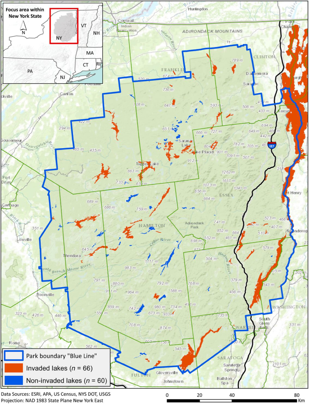
Figure 1. Study area map of 126 lakes within the Adirondack Park region of New York, United States (43°56ʹ N, 74°23ʹ W).
In this project, we used publicly available data collected by agencies such as the Adirondack Park Invasive Plant Program, U.S. Census, Department of Transportation, and NY Department of Environmental Conservation (see Table 1 within paper for complete list of sources) to identify important lake and landscape characteristics that are associated with aquatic invasion in 126 Adirondack Lakes (Figure 1).
Lake and landscape characteristics are the interconnections of the terrestrial and aquatic attributes associated with the lake’s riparian zone. Lake and landscape characteristics provide research, planning and management information about aquatic invasive species’ initial dispersal, spread, and establishment. Using spatially enabled statistical modeling (Geographically Weighted Regression; GWR), we were able to predict up to 83% of the variation of aquatic invasive species richness across five different models.
Publicly accessible data can help manage risk
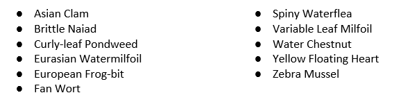
Using lake and riparian landscape patterns, an assessment of the propagation of harmful aquatic invasive species was made. In doing so, a simple measure of aquatic invasive species richness was created by summing the presence of the following 11 invasive species across the 126 Adirondack lakes. Presence or absence data of the aquatic invaders were found within the publicly available annual report published by Adirondack Park Invasive Plant Program (APIPP).
The simple ecological index, aquatic invasive species richness, was spatial analyzed. Using this aquatic invasion index, a “hot spot” and “cold spot” analysis was conducted across the 126 study area lakes. Hot spot analysis compares the number of invaders in one lake to the number of invaders in neighboring lakes, with the neighboring lakes established within a 50 km distance. Significant spatial “hot and cold spots” of aquatic invasive species richness were illustrated across the 126 Adirondack lakes (Figure 2).
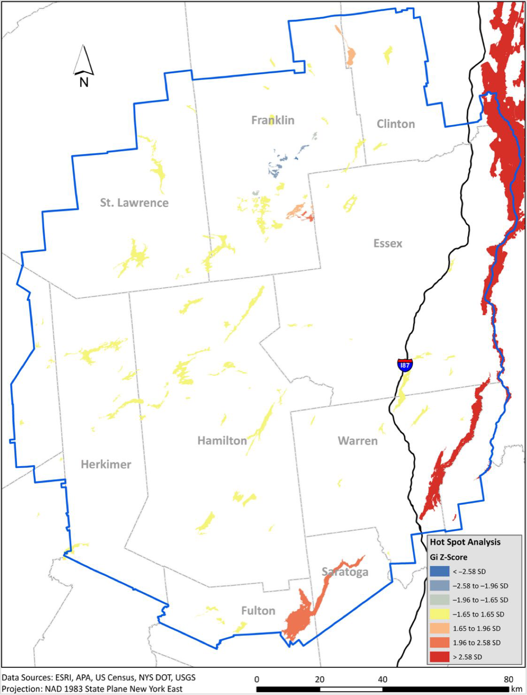
Figure 2. Hot spot analysis of aquatic invasive species richness across the 126 study area lakes.
Four statistically significant hot spots and one cold spot were identified. The most significant hot spot stretched from Lake Champlain south to Hadlock Pond along the eastern side of the Park on the I-87 corridor, and includes Lake George. The second most significant hotspot is in the 1932/1980 Winter Olympic region of the Park. The third hot spot focused around Kiwassa Lake and includes Saranac Lake (Lower), Oseetah Lake, Lake Flower, First Pond—Saranac River, and Second Pond—Saranac River. The last two marginally significant hot spots are focused on Great Sacandaga Lake in the south and one at Chateaugay Lake (Upper) in the north. The single significant cold spot focused at Jones Pond, in the central part of Franklin County, and stretched from Lake Kushaqua on its northeast end to Hoel Pond on its southwest end.
When investigating causal factors, this research found positive and negative predictors of aquatic invasion across 126 Adirondack lakes. Positive predictors are things that are linked to the dispersal, spread, and establishment of invasive species while negative predictors impede them. The presence of aquatic invasive species was linked to both human induced as well as natural pathways. One of the most important findings was that higher lake surface elevation, along with increased riparian forest covers, decreased the presence of aquatic invaders. Spatial and statistical analyses agreed that the strongest predictors of Adirondack aquatic invasion were:
● Distance to nearest invaded lake – The farther a lake is from invaders the less likely it is to be invaded. Conversely, the closer a lake is to another invaded lake the more likely it is to be invaded.
● Percent urban land cover within the riparian zone – As urban land cover increases, such as loss of canopy cover to human built environments, the risk to invasion increases.
● Lake elevation – As the lake elevation increases the risk of invasion decreases.
● Distance to I-87 exit – The nearer a lake is to an I-87 exit, the more likely it is to be at heightened risk for invasion.
● Abundance of game fish – The more game fish that are present in a lake the higher the risk of invasive species.
The combined predictive results from the five lake and landscape models were used to create a prioritization table of lakes susceptible to future invasion. The following list ranks the top 20 lakes, from the original 126 lakes assessed, using various combinations of the above listed lake and landscape predictors.
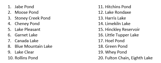
From the 126 lakes assessed, Figure 3 illustrates the locations of the aforementioned top 20 lakes at risk to future aquatic invasion within the Adirondack Park.
Figure 3. Map illustrating the location and rank of the top 20 lakes (from the 126 assessed) at risk to aquatic invasion.
Concluding thoughts
According to Waldo Tobler’s “First Law of Geography” “everything is related to everything else, but near things are more related than distant things.” This study uses a landscape ecology and macroscale spatial analysis approach to fulfill its aquatic invasive research objectives. What we have done differently from other invasive research is to include the natural unequal variation of relationships across space. Incorporating that neighboring lake and landscape conditions have greater influence on aquatic invasion than further ones.
Areas where people congregate, as well as their activities related to freshwater recreation, are the main human-based propagators of invasive species for the lakes evaluated. Based on our analysis the distance to the nearest invaded lake is the most significant predictor of Adirondack aquatic invasion. The second most significant predictor was the distance between a lake and nearest I-87 exit, while the third was lake surface elevation.
Despite a strong commitment by governmental and non-governmental organizations, it remains financially and logistically impossible to evaluate all lakes within the Adirondack Park annually. This means that aquatic invaders could propagate through waterways bypassed when environmental managers choose their monitoring programs. Therefore, improving modeling methods that accurately predict which lakes are most susceptible to invasion greatly aids in strategic placement of limited monitoring and management resources.
Citation
Shaker, R. R., A. D. Yakubov, S. M. Nick, E. Vennie-Vollrath, T. J. Ehlinger, and K. Wayne Forsythe. 2017. Predicting aquatic invasion in Adirondack lakes: a spatial analysis of lake and landscape characteristics. Ecosphere 8(3):e01723. 10.1002/ecs2.1723